File:Provinces of France.png
Vai alla navigazione
Vai alla ricerca
Dimensioni di questa anteprima: 596 × 599 pixel. Altre risoluzioni: 239 × 240 pixel | 477 × 480 pixel | 894 × 899 pixel.
File originale (894 × 899 pixel, dimensione del file: 39 KB, tipo MIME: image/png)

|
File:Provinces of France (numered-monochrome).svg è una versione vettoriale di questo file. Dovrebbe essere usata quella versione al posto di questo file PNG, quando sia migliore.
File:Provinces of France.png → File:Provinces of France (numered-monochrome).svg
Per maggiori informazioni, vedi Help:SVG. |
.svg) |
Dettagli
Español: Provincias de Francia
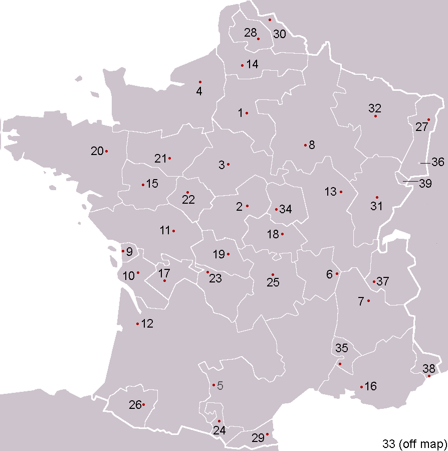
Pre-Republican provinces of France, numbered according to union with France, with provincial capitals marked.
Created by reference to a 1952 Nouveau Petit Larousse by User:OwenBlacker and licenced under the GFDL.
Provinces as follows, in the format English name (French name, Year of union; Capital):
- Royal Domain (Île-de-France, 987, Paris)
- Berry (Berry, 1101, Bourges)
- Duchy of Orléanais (Orléanais, 1198, Orléans)
- Normandy (Normandie, 1204, Rouen)
- Languedoc, mainly the County of Toulouse (Languedoc, 1270, Toulouse)
- Lyonnais (Lyonnais, 1313, Lyon)
- Dauphiné, (Dauphiné, 1349, Grenoble)
- County of Champagne (Champagne, 1361, Troyes)
- Aunis, a fief of Aquitaine (Aunis, 1371, La Rochelle)
- Saintonge (Saintonge, 1371, Saintes)
- Poitou (Poitou, 1416, Poitiers)
- Duchy of Aquitaine (Aquitaine, 1453, Bordeaux), taken from England and split into provinces of Gascogne (Armagnac) and Guyenne (Bordeaux), but excluding the viscounties of Foix, Béarn, Bigorre and Périgord (kept by Navarre)
- Duchy of Burgundy (Bourgogne, 1477, Dijon)
- Picardy (Picardie, 1482, Amiens)
- Anjou (Anjou, 1482, Angers)
- County of Provence (Provence, 1482, Aix-en-Provence)
- County of Angoulême (Angoumois, 1515, Angoulême)
- Duchy of Bourbon (Bourbonnais, 1527, Moulins)
- La Marche (Marche, 1527, Guéret)
- Duchy of Britanny (Bretagne, 1532, Rennes)
- County of Maine (Maine, 1584, Le Mans) and County of Perche (Perche, 1525, Nogent-le-Rotrou)
- Touraine (Touraine, 1584, Tours)
- Limousin (Limousin, 1589, Limoges), excluding Viscounty of Périgord (kept by Navarre)
- County of Foix (Comté de Foix, 1607, Foix) and Viscounty of Périgord (Périgord, 1607, Périgueux, attached to province of Guyenne), both former fiefs from Navarre
- Duchy of Auvergne (Auvergne, 1610, Clermont-Ferrand)
- Viscounty of Béarn (Béarn, 1620, Pau)
- Alsace (Alsace, 1648, Strasbourg)
- County of Artois, a fief of the w:Habsburgs' Spanish Netherlands (Artois, 1659, Arras)
- Roussillon (Roussillon, 1659, Perpignan)
- Flanders, a fief of the w:Habsburgs' Spanish Netherlands (Flandre, 1668, Lille)
- Free County of Burgundy (Franche-Comté, 1678, Besançon)
- Duchy of Lorraine, a personal territory of Stanisław I of Poland within the Holy Roman Empire (Lorraine, 1766, Nancy)
- Corsica (off map, Corse, 1768, Ajaccio)
The following were not provinces of France before the Revolution, but joined or were annexed to France after it, when departments had replaced all former provinces: - Duchy of Nivernais (Nivernais, 1789, Nevers)
- Comtat Venaissin, a Papal fief (Comtat Venaissain, 1791, Avignon)
- Imperial Free City of Mulhouse (Mulhouse, 1798)
- Duchy of Savoy, a state of the Kingdom of Sardinia-Piedmont (Savoie, 1860, Chambéry)
- County of Nice, a state of the Kingdom of Sardinia-Piedmont (Comté de Nice, 1860, Nice)
- Principality of Montbéliard (Montbéliard, 1816, Montbéliard)
- Free cities of Menton and Roquebrune (1861), joining France after the separation (under the protectorate of Sardinia) in 1848 from Monaco

|
È permesso copiare, distribuire e/o modificare questo documento in base ai termini della GNU Free Documentation License, Versione 1.2 o successive pubblicata dalla Free Software Foundation; senza alcuna sezione non modificabile, senza testo di copertina e senza testo di quarta di copertina. Una copia della licenza è inclusa nella sezione intitolata Testo della GNU Free Documentation License. |
| Questo file è disponibile in base alla licenza Creative Commons Attribuzione-Condividi allo stesso modo 3.0 Unported | ||
| ||
| Questo tag di copyright è stato aggiunto nell'ambito dell'aggiornamento della licenza dei progetti Wikimedia. |
derivative works
Opere derivate da questo file: Forteresses marches de Bretagne.png
Cronologia del file
Fare clic su un gruppo data/ora per vedere il file come si presentava nel momento indicato.
| Data/Ora | Miniatura | Dimensioni | Utente | Commento | |
|---|---|---|---|---|---|
| attuale | 01:53, 5 feb 2005 | | 894 × 899 (39 KB) | wikimediacommons>OwenBlacker | Corrected map |
Utilizzo del file
La seguente pagina usa questo file: